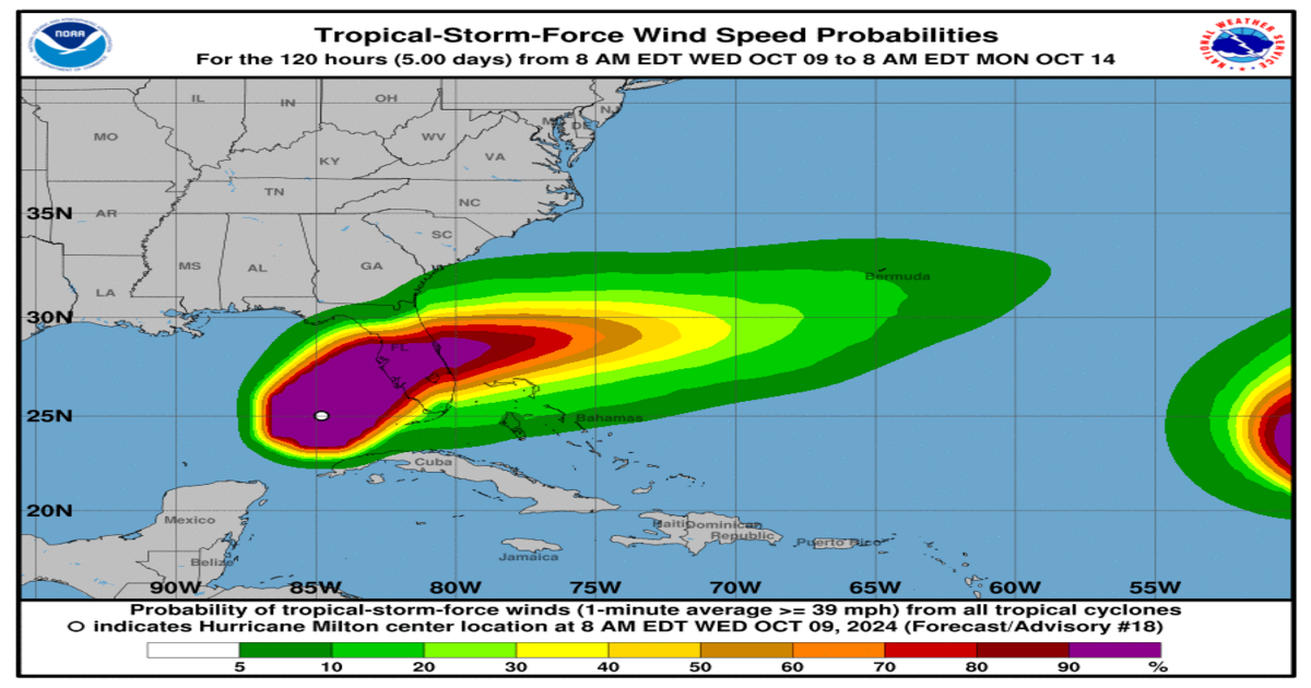
Hurricane Milton wind speed probabilities ,image credit-www.nhc.noaa.gov
Hurricane Milton, now a Category 4 storm, is moving relentlessly closer to Florida’s west coast, bringing with it severe weather that is already beginning to affect the state. The National Hurricane Center (NHC) warns that Milton, which rapidly strengthened into a Category 5 hurricane earlier this week, remains a dangerous storm capable of causing widespread destruction, even after slightly weakening.
As the storm edges nearer, tornadic supercells have begun sweeping across southern Florida, intensifying the threat of severe weather across the region. Residents in Tampa, Orlando, and surrounding areas are urged to complete emergency preparations as conditions are expected to deteriorate throughout Wednesday. Officials warn of dangerous storm surges, torrential rainfall, flash floods, and powerful winds.
Tornado and Severe Weather Threat Looms Over Florida
Milton’s approach brings the potential for tornadoes across much of southern and central Florida, adding to the already significant concerns about flooding and damaging winds. Tornadic activity associated with the hurricane’s outer bands can develop suddenly, with little warning, leaving residents with only moments to seek shelter.
Meteorologists are particularly concerned about the storm’s capacity to create multiple tornadoes, which can be especially dangerous during the night when they are harder to detect. These rotating storms could wreak havoc on homes, businesses, and infrastructure, even far from Milton’s direct landfall zone.
Hurricane Milton’s Path and Landfall
At 8 a.m., the NHC reported that Hurricane Milton had weakened slightly but maintained Category 4 strength, with maximum sustained winds of 145 mph. The storm was last tracked about 175 miles southwest of Tampa, moving northeast at 17 mph. While the precise point of landfall remains uncertain, current projections suggest that Milton will make landfall along Florida’s west coast by late Wednesday night or early Thursday morning.
The NHC stresses that Tampa and nearby coastal areas should brace for the storm’s full impact. Depending on its speed, Milton may move off Florida’s east coast and into the Atlantic Ocean by Thursday afternoon. However, before it exits the state, Milton is expected to unleash significant rainfall, high winds, and flash flooding across a wide area.
Impacts of Milton: Flooding, Winds, and Storm Surge
The most significant threats posed by Hurricane Milton include storm surge, flash flooding, and destructive winds. Residents living near the coast are at high risk from storm surges, with officials warning that these surges could push water levels dangerously high, creating large and destructive waves. The extent of the flooding will largely depend on Milton’s timing and the tide cycle when it makes landfall.
Additionally, the NHC warns of catastrophic rainfall, with some areas of Florida expected to receive as much as 18 inches of rain. This level of precipitation could cause life-threatening flash floods, especially in urban areas and along rivers. Moderate to major river flooding is also a possibility.
Alongside the rain and storm surge, winds of up to 145 mph will likely cause widespread damage to homes, power lines, and infrastructure, particularly in areas closest to the storm’s path. Residents are urged to secure any loose objects and prepare for extended power outages as the storm moves inland.
Central Florida Braces for Flash Floods and Tornadoes
Residents of Orlando and central Florida are already under tropical storm advisories as they brace for intense impacts from Hurricane Milton. The region, while not in the direct path of the storm, is still expected to experience flash flooding, tornadoes, and torrential rain.
Forecasters are particularly concerned about the threat of tornadoes in Orlando, as Milton’s outer bands sweep through the area. In addition to tornadoes, parts of central Florida could see wind gusts topping 100 mph, enough to cause significant structural damage, power outages, and downed trees.
Urgent Evacuations and Preparations
In its latest advisory, the NHC stressed that preparations, including evacuations, should be rushed to completion by Wednesday morning. With conditions expected to deteriorate rapidly, local officials are urging residents to follow evacuation orders, particularly those living in coastal or flood-prone areas.
Evacuation zones have been established across several counties, and shelters are open for those unable to find refuge elsewhere. It is crucial to have multiple ways to receive weather alerts, such as radio, television, or mobile notifications, in case of rapidly changing conditions.
FAQs: Florida Tornado Threat Amid Hurricane Milton
Q: How does Hurricane Milton increase the risk of tornadoes in Florida?
A: The outer bands of hurricanes like Milton can create tornadic supercells, which are capable of producing multiple tornadoes. These storms can form quickly, leaving little time for warning and response, especially in the southern and central regions of Florida.
Q: How can I protect myself from tornadoes during a hurricane?
A: If a tornado warning is issued, seek shelter immediately in a basement or an interior room on the lowest floor of a sturdy building, away from windows. Do not shelter in mobile homes or vehicles.
Q: What are the most dangerous impacts of Hurricane Milton?
A: The greatest threats include storm surge, which can flood coastal areas, flash flooding from intense rainfall, and damaging winds that could cause structural damage and power outages. Tornadoes are an additional threat, especially in southern and central Florida.
Q: When is Hurricane Milton expected to make landfall?
A: Milton is expected to make landfall along Florida’s west coast late Wednesday night or early Thursday morning. The storm is likely to move off the east coast of Florida by Thursday afternoon.
Q: What should I do if I am under a hurricane or tornado warning?
A: Follow all evacuation orders, and if sheltering in place, ensure you are in a secure location. Monitor local news and NHC advisories for updates, and be prepared to take cover if a tornado warning is issued.
As Hurricane Milton inches closer to Florida, the combination of severe weather, tornadoes, and flooding threatens to devastate communities across the state. Residents are urged to remain vigilant and follow all emergency advisories.
